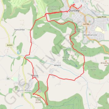
Tyndale from Dursley
Loop hike via Cockshoot Wood, Tyndale Monument, Nibley Knoll, Ashen Plains Wood, Gravelpit Wood and Hermitage Wood in the Cotswolds National Landscape. #Hike #Loop #Nature #Forest #Countryside #Cotswolds
- Distance: 7.0 mi
- Elevation gain: 1,427 ft
- Maximum elevation: 659 ft
- Elevation loss: 1,476 ft
- Minimum elevation: 184 ft
- Moving time: 2 h 41 m
- Moving speed: 2.6 mph
- Maximum speed: 5.9 mph
- Total time: 3 h 47 m
- Global speed: 1.8 mph
- Date: 04/07/2024
Interactive map
GPS track profile
About this GPS track
Name: Tyndale from Dursley GPS track, route, trail
Coordinates: 51.65603 -2.37656 51.68285 -2.35054
Other GPS tracks
Click on a GPS track to view route, its statistics and profile.
Dean2023-311
United Kingdom > England > Oxfordshire > Oxford
Distance: 192.8 mi • Elevation gain: 11,043 ft • Maximum elevation: 951 ft