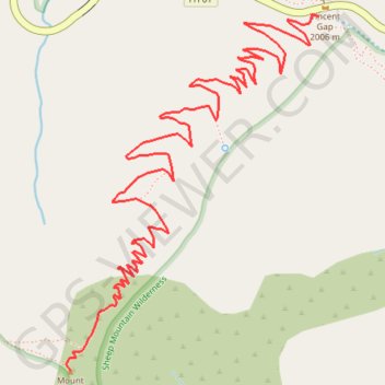
Mount Baden-Powell
Hike from Vincent Gap to Mount Baden-Powell via the Pacific Crest Trail (PCT) in the San Gabriel Mountains National Monument and the Angeles National Forest. #Hike #Mountain #Nature #Forest #Angeles
- Distance: 3.9 mi
- Elevation gain: 2,812 ft
- Maximum elevation: 9,373 ft
- Elevation loss: 49 ft
- Minimum elevation: 6,611 ft
Interactive map
GPS track profile
About this GPS track
Name: Mount Baden-Powell GPS track, route, trail
Coordinates: 34.35849 -117.76488 34.37308 -117.75233
Topography: Los Angeles County topographic map
Other GPS tracks
Click on a GPS track to view route, its statistics and profile.