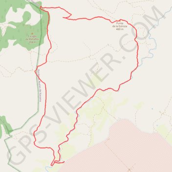
Bardenas Reales - Castillo de Penaflor
Interactive map
GPS track profile
About this GPS track
Name: Bardenas Reales - Castillo de Penaflor GPS track, route, trail
Start: Bardenas Reales de Navarra, Erribera / Ribera, Espagne (42.21926 -1.50778)
End: Bardenas Reales de Navarra, Erribera / Ribera, Espagne (42.21924 -1.50777)
Coordinates: 42.21823 -1.51830 42.25903 -1.48224
Other GPS tracks
Click on a GPS track to view route, its statistics and profile.
Southern section — European Divide Trail
France > Auvergne-Rhône-Alpes > Drôme > Valence
Distance: 1,506.1 mi • Elevation gain: 139,026 ft • Maximum elevation: 6,578 ft
EuroVelo 1 (Spain)
Espagne > Andalousie > Côte occidentale > Ayamonte
Distance: 842.4 mi • Elevation gain: 47,858 ft • Maximum elevation: 4,331 ft
Chemin de Saint-Jacques-de-Compostelle de Saint-Germain-des-Prés à Cap Finisterre
France > Centre-Val de Loire > Loiret > Saint-Germain-des-Prés > Montantaume
Randonnée. En aller simple entre Saint-Germain-des-Prés et Fisterra. #Randonnée #Compostelle
Distance: 1,358.7 mi • Elevation gain: 141,211 ft • Maximum elevation: 5,276 ft
Trace 4X4 traversée des Pyrénées
France > Occitanie > Pyrénées-Orientales > Collioure
De Collioure à Saint-Jean-Pied-de-Port avec une boucle dans les Bardenas. #Pyrénées
Distance: 741.1 mi • Elevation gain: 105,617 ft • Maximum elevation: 6,755 ft
Eurovelo 01 Spain + Portugal
France > Nouvelle-Aquitaine > Pyrénées-Atlantiques > Hendaye
Distance: 1,930.7 mi • Elevation gain: 100,367 ft • Maximum elevation: 4,931 ft
Trace 4X4 Pyrénées traversée
France > Occitanie > Pyrénées-Orientales > Collioure
Distance: 740.8 mi • Elevation gain: 104,879 ft • Maximum elevation: 6,755 ft
Camino Francés (Chemin des Français)
France > Nouvelle-Aquitaine > Pyrénées-Atlantiques > Saint-Jean-Pied-de-Port > Larroinea
Pèlerinage de Saint-Jacques-de-Compostelle depuis Saint-Jean-Pied-de-Port. #Randonnée #Compostelle #Espagne #Pyrénées #Nature #Campagne #Montagne #Cantabrica #Cantabrique
Distance: 466.6 mi • Elevation gain: 38,353 ft • Maximum elevation: 4,954 ft
Trace 4X4 Pyrénées traversée
France > Occitanie > Pyrénées-Orientales > Collioure
Distance: 740.8 mi • Elevation gain: 104,879 ft • Maximum elevation: 6,755 ft
Trace 4X4 Pyrénées traversée.
France > Occitanie > Pyrénées-Orientales > Collioure
Distance: 880.7 mi • Elevation gain: 131,732 ft • Maximum elevation: 6,755 ft
Compostelle a Velo - ESPAGNE
Espagne > Pirinioak / Pirineo > Roncevaux
Distance: 611.1 mi • Elevation gain: 45,466 ft • Maximum elevation: 4,938 ft
Bardenas_Andorre_Mediterranee
Bardenas_Andorre_Mediterranee
Distance: 628.2 mi • Elevation gain: 80,394 ft • Maximum elevation: 7,264 ft
1 LUCENA - MONTPELLIER
Distance: 1,842.0 mi • Elevation gain: 96,785 ft • Maximum elevation: 3,438 ft
1 LUCENA - MONTPELLIER
Espagne > Andalousie > Lucena
Distance: 1,842.0 mi • Elevation gain: 96,785 ft • Maximum elevation: 3,438 ft
Track liberty-2023-11-28T20:36:34.359Z
France > Nouvelle-Aquitaine > Pyrénées-Atlantiques > Anglet
Distance: 1,263.7 mi • Elevation gain: 172,766 ft • Maximum elevation: 8,012 ft
Track liberty-2023-12-31T07:19:49.479Z
France > Nouvelle-Aquitaine > Pyrénées-Atlantiques > Anglet
Distance: 1,264.5 mi • Elevation gain: 173,855 ft • Maximum elevation: 7,956 ft
CAMINO FRANCES 1ª PARTE 001
France > Nouvelle-Aquitaine > Pyrénées-Atlantiques > Saint-Jean-Pied-de-Port > Larroinea
Distance: 468.2 mi • Elevation gain: 38,419 ft • Maximum elevation: 4,951 ft
Track liberty-2023-11-18T06:38:38.493Z
France > Nouvelle-Aquitaine > Pyrénées-Atlantiques > Saint-Jean-de-Luz
Distance: 804.5 mi • Elevation gain: 86,877 ft • Maximum elevation: 5,190 ft
Trace 4X4 Pyrénées traversée.
France > Occitanie > Pyrénées-Orientales > Collioure
Distance: 628.0 mi • Elevation gain: 68,652 ft • Maximum elevation: 6,745 ft
Camino Frances Main Track
France > Nouvelle-Aquitaine > Pyrénées-Atlantiques > Saint-Jean-Pied-de-Port > Larroinea
Distance: 534.0 mi • Elevation gain: 50,072 ft • Maximum elevation: 4,941 ft
Stage 26: Valence to Saint-Jean-de-Fos — European Divide Trail
France > Auvergne-Rhône-Alpes > Drôme > Valence
Distance: 1,506.1 mi • Elevation gain: 139,026 ft • Maximum elevation: 6,578 ft
EuroVelo 1 (Spain)
Espagne > Andalousie > Côte occidentale > Ayamonte > Pozo del Camino > Fotea
Distance: 838.7 mi • Elevation gain: 44,754 ft • Maximum elevation: 4,331 ft
Bardenas - Castillo de Peñaflor, mesa de la Estroza, Barranco Grande. - 4865 - UtagawaVTT.com
Espagne > Erribera / Ribera > Bardenas Reales de Navarra
Bardenas Reales - Castillo de Peñaflor, mesa de la Estroza, Barranco Grande
Distance: 18.9 mi • Elevation gain: 1,329 ft • Maximum elevation: 1,506 ft
(tous)_saint_Jacques_de_Compostelle_1600Km
France > Auvergne-Rhône-Alpes > Haute-Loire > Le Puy-en-Velay
Distance: 1,000.5 mi • Elevation gain: 97,608 ft • Maximum elevation: 4,928 ft
Kiki jour 1
France > Nouvelle-Aquitaine > Pyrénées-Atlantiques > Orthez
Distance: 178.0 mi • Elevation gain: 19,537 ft • Maximum elevation: 4,314 ft
Stage 26: Valence to Saint-Jean-de-Fos — European Divide Trail
France > Auvergne-Rhône-Alpes > Drôme > Valence
Distance: 1,012.7 mi • Elevation gain: 101,184 ft • Maximum elevation: 6,578 ft
De Villeneuve-sur-Lot à Guimarães
France > Nouvelle-Aquitaine > Lot-et-Garonne > Villeneuve-sur-Lot
Distance: 1,257.8 mi • Elevation gain: 72,575 ft • Maximum elevation: 4,393 ft
Saint Jean Pied de Port - Fiesterra
France > Nouvelle-Aquitaine > Pyrénées-Atlantiques > Saint-Jean-Pied-de-Port > Larroinea
Distance: 473.0 mi • Elevation gain: 40,036 ft • Maximum elevation: 4,928 ft
10/08/2022 07:45:45
Espagne > Catalogne > Haut-Ampurdan > Llançà
10/08/2022 07:45:45
Distance: 577.5 mi • Elevation gain: 83,776 ft • Maximum elevation: 6,847 ft
Trace
France > Nouvelle-Aquitaine > Pyrénées-Atlantiques > Saint-Jean-Pied-de-Port > Larroinea
Distance: 472.3 mi • Elevation gain: 40,712 ft • Maximum elevation: 4,954 ft