Around Kirkmichael, Perthshire
- Distance: 4.8 mi
- Elevation gain: 289 ft
- Maximum elevation: 899 ft
- Elevation loss: 289 ft
- Minimum elevation: 699 ft
- Moving time: 56 m 55 s
- Moving speed: 5.1 mph
- Maximum speed: 17.5 mph
- Total time: 1 h 22 m
- Global speed: 3.5 mph
- Date: 04/27/2024
Interactive map
GPS track profile
About this GPS track
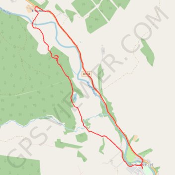
Name: Around Kirkmichael, Perthshire GPS track, route, trail
Start: A924, Kirkmichael, Perth and Kinross, Scotland, PH10 7NT, United Kingdom (56.72301 -3.50498)
End: A924, Kirkmichael, Perth and Kinross, Scotland, PH10 7NT, United Kingdom (56.72305 -3.50502)
Coordinates: 56.72239 -3.53595 56.74741 -3.50472
Other GPS tracks
Click on a GPS track to view route, its statistics and profile.
Alyth to Spittal of Glenshee - Cateran Trail (some of)
United Kingdom > Scotland > Perth and Kinross > Alyth
Distance: 27.4 mi • Elevation gain: 3,720 ft • Maximum elevation: 2,133 ft