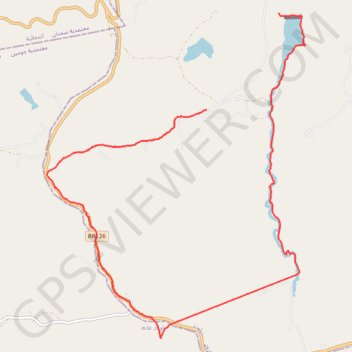
Oued zitoun
Randonnée pédestre. En aller simple. #Randonnée
- Distance: 7.3 mi
- Elevation gain: 1,263 ft
- Maximum elevation: 1,604 ft
- Elevation loss: 1,099 ft
- Minimum elevation: 656 ft
Interactive map
GPS track profile
About this GPS track
Name: Oued zitoun GPS track, route, trail
Start: RR126, Dhouaouda, Délégation Ghezala, Gouvernorat Bizerte, Tunisie (37.03473 9.38229)
End: RR126, Dhouaouda, Délégation Ghezala, Gouvernorat Bizerte, Tunisie (37.02367 9.37192)
Coordinates: 36.99736 9.34895 37.03473 9.38610