Allen Mountain
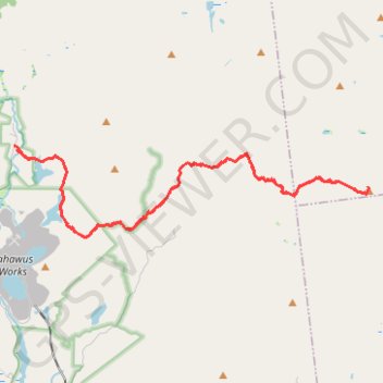
Hike / snowshoes from East River Parking to Allen Mountain via East River Trail, Hudson River, Lake Jimmy, Lake Sally, Allen Mountain Trail and Allen Lookout North in the High Peaks Wilderness and the Adirondack Park. #Hike #Snowshoes #Mountain #Nature #Forest #Lake #River #Park #Wilderness #Adirondack
- Distance: 17.8 mi
- Elevation gain: 3,478 ft
- Maximum elevation: 4,272 ft
- Elevation loss: 3,478 ft
- Minimum elevation: 1,752 ft
- Moving time: 8 h 41 m
- Moving speed: 2.1 mph
- Maximum speed: 3.0 mph
- Total time: 10 h 38 m
- Global speed: 1.7 mph
- Date: 03/06/2010
Interactive map
GPS track profile
About this GPS track
Name: Allen Mountain GPS track, route, trail
Coordinates: 44.05965 -74.05528 44.08120 -73.93967
Topography: Essex County topographic map
Other GPS tracks
Click on a GPS track to view route, its statistics and profile.
Montréal - New York
Canada > Québec > Agglomération de Montréal > Montréal
Distance: 396.0 mi • Elevation gain: 13,563 ft • Maximum elevation: 988 ft