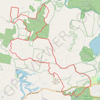
Tinbeerwah - Tewantin National Park - Ringtail State Forest
#MTB #Loop #Tinbeerwah #Tewantin #Ringtail
- Distance: 30.3 mi
- Elevation gain: 2,320 ft
- Maximum elevation: 719 ft
- Elevation loss: 2,320 ft
- Minimum elevation: 20 ft
Interactive map
GPS track profile
About this GPS track
Name: Tinbeerwah - Tewantin National Park - Ringtail State Forest GPS track, route, trail
Start: Wooroi Track, Tewantin, Noosa Shire, Queensland, 4565, Australia (-26.39944 153.01024)
End: Wooroi Track, Tewantin, Noosa Shire, Queensland, 4565, Australia (-26.39944 153.01027)
Coordinates: -26.40851 152.92213 -26.31353 153.01550
Other GPS tracks
Click on a GPS track to view its route, statistics and profile.
Loop on Mount Tinbeerwah in Tewantin National Park
Australia > Queensland > Tewantin
Distance: 10.8 mi • Elevation gain: 1,079 ft • Maximum elevation: 692 ft
Mount Tinbeerwah ride in Tewantin National Park
Australia > Queensland > Tewantin
Distance: 14.3 mi • Elevation gain: 1,473 ft • Maximum elevation: 459 ft
Imbil Jimna Kenilworth loop
Australia > Queensland > Tewantin
Distance: 134.2 mi • Elevation gain: 12,743 ft • Maximum elevation: 2,697 ft