Mount Umunhum
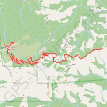
Hike to Mount Umunhum via Mount Umunhum Trail and Guadalupe Creek Overlook in the Sierra Azul Open Space Preserve. #Hike #Mountain #Nature #Forest #Overlook
- Distance: 7.5 mi
- Elevation gain: 2,077 ft
- Maximum elevation: 3,432 ft
- Elevation loss: 2,080 ft
- Minimum elevation: 2,254 ft
- Moving time: 2 h 39 m
- Moving speed: 2.8 mph
- Maximum speed: 5.5 mph
- Total time: 2 h 57 m
- Global speed: 2.5 mph
- Date: 01/21/2018
Interactive map
GPS track profile
About this GPS track
Name: Mount Umunhum GPS track, route, trail
Coordinates: 37.15613 -121.90088 37.16075 -121.87564
Topography: Santa Clara County topographic map