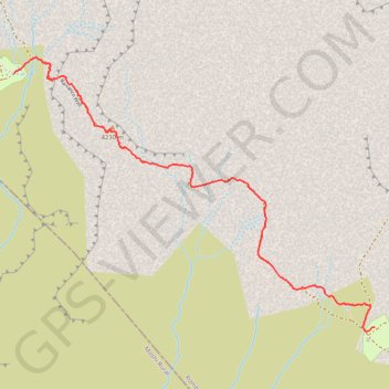
Machame - J4
Randonnée pédestre. En aller simple. #Randonnée
- Distance: 3.0 mi
- Elevation gain: 1,365 ft
- Maximum elevation: 13,832 ft
- Elevation loss: 1,148 ft
- Minimum elevation: 12,953 ft
Interactive map
GPS track profile
About this GPS track
Name: Machame - J4 GPS track, route, trail
Start: Barranco Camp, Barranco Wall, Rombo, Kilimandjaro, Northern Zone, Tanzanie (-3.09507 37.33041)
End: Karanga Camp, Barranco Wall, Rombo, Kilimandjaro, Northern Zone, Tanzanie (-3.11201 37.35451)
Coordinates: -3.11231 37.33041 -3.09398 37.35451
Other GPS tracks
Click on a GPS track to view route, its statistics and profile.
Kilimanjaro - Voie Lemosho 9 jours
Randonnée pédestre. #Randonnée
Distance: 31.3 mi • Elevation gain: 11,667 ft • Maximum elevation: 19,281 ft
Machame - J5
Randonnée pédestre. En aller simple. #Randonnée
Distance: 2.2 mi • Elevation gain: 2,077 ft • Maximum elevation: 15,279 ft
Machame - J3
Randonnée pédestre. En aller simple. #Randonnée
Distance: 6.5 mi • Elevation gain: 2,740 ft • Maximum elevation: 15,207 ft
Machame - J6
Randonnée pédestre. #Randonnée
Distance: 8.4 mi • Elevation gain: 4,012 ft • Maximum elevation: 19,262 ft