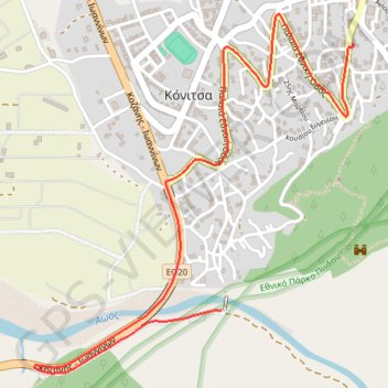
7 Μαρ 2024 11:55:49 π.μ.
- Distance: 2.6 mi
- Elevation gain: 121 ft
- Maximum elevation: 1,978 ft
- Elevation loss: 614 ft
- Minimum elevation: 1,440 ft
- Moving time: 7 m 58 s
- Moving speed: 19.7 mph
- Maximum speed: 44.6 mph
- Total time: 7 m 58 s
- Global speed: 19.7 mph
- Date: 03/07/2024
Interactive map
GPS track profile
About this GPS track
Name: 7 Μαρ 2024 11:55:49 π.μ. GPS track, route, trail
Coordinates: 40.03374 20.73570 40.04730 20.75142
Topography: Ioannina Regional Unit topographic map
Other GPS tracks
Click on a GPS track to view route, its statistics and profile.
Albanie j1j2 579kms
Grèce > Épire-Macédoine occidentale > Περιφερειακή Ενότητα Θεσπρωτίας > Λάκκα
Distance: 356.3 mi • Elevation gain: 85,889 ft • Maximum elevation: 7,264 ft