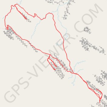
Devil's Garden Trail
Loop hike in the Arches National Park via Devil's Garden Trail, Landscape Arch Viewpoint, Navajo Arch Trail, Partition Arch Trail, Black Arch Overlook, Double O Arch Trail, Private Arch Trail, Pine Tree Arch Trail and Pine Tree Arch Viewpoint. #Hike #Loop #Nature #Rock #Park #Mountain #Overlook #Desert
- Distance: 6.4 mi
- Elevation gain: 1,010 ft
- Maximum elevation: 5,505 ft
- Elevation loss: 1,001 ft
- Minimum elevation: 5,039 ft
- Moving time: 3 h 1 m
- Moving speed: 2.1 mph
- Maximum speed: 3.5 mph
- Total time: 3 h 12 m
- Global speed: 2.0 mph
- Date: 06/28/2017
Interactive map
GPS track profile
About this GPS track
Name: Devil's Garden Trail GPS track, route, trail
Start: Devil's Garden Trail, Grand County, Utah, United States (38.78499 -109.59768)
End: Devil's Garden Trail, Grand County, Utah, United States (38.78464 -109.59771)
Coordinates: 38.78464 -109.62167 38.80415 -109.59701
Topography: Grand County topographic map
Other GPS tracks
Click on a GPS track to view route, its statistics and profile.
Arches National Park Loop
United States > Utah > Grand County
Loop hike via Devil's Garden Trail, Pine Tree Arch Trail, Tunnel Arch Viewpoint, Pine Tree Arch Viewpoint, Devil's Garden Primitive Trail Loop, Private Arch Trail, Dark Angel Trail, Dark Viewpoint, Double O Arch Trail, Black Arch Overlook Trail, Navajo Arch Trail, Partition Arch Trail and Landscape Arch Viewpoint in the Arches…
Distance: 8.4 mi • Elevation gain: 1,381 ft • Maximum elevation: 5,515 ft