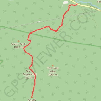
North Tripyramid, Middle Tripyramid and South Tripyramid
Hike to North Tripyramid, Middle Tripyramid and South Tripyramid via Pine Bend Brook Trail and Mount Tripyramid Trail in the Sandwich Range Wilderness and the White Mountain National Forest. #Hike #Mountain #Nature #Forest
- Distance: 9.6 mi
- Elevation gain: 3,346 ft
- Maximum elevation: 4,081 ft
- Elevation loss: 3,346 ft
- Minimum elevation: 1,368 ft
- Moving time: 4 h 52 m
- Moving speed: 2.0 mph
- Maximum speed: 3.5 mph
- Total time: 6 h 14 m
- Global speed: 1.5 mph
- Date: 09/03/2023
Interactive map
GPS track profile
About this GPS track
Name: North Tripyramid, Middle Tripyramid and South Tripyramid GPS track, route, trail
Start: Kancamagus Highway, Livermore, Grafton County, New Hampshire, United States (44.00196 -71.41320)
End: Kancamagus Highway, Livermore, Grafton County, New Hampshire, United States (44.00192 -71.41320)
Coordinates: 43.96011 -71.44643 44.00196 -71.41309
Topography: Grafton County topographic map
Other GPS tracks
Click on a GPS track to view route, its statistics and profile.
Tripyramid Mountains Loop
United States > New Hampshire > Grafton County > Waterville Valley
Loop hike from Livermore South Trailhead to North Tripyramid, Middle Tripyramid and South Tripyramid via Livermore Road, Avalanche Brook, Mount Tripyramid Trail and Slide Brook in the Sandwich Range Wilderness. #Hike #Loop #Mountain #Forest #Nature #Wilderness
Distance: 10.6 mi • Elevation gain: 2,802 ft • Maximum elevation: 4,088 ft