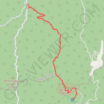
7-9-10 Staza br.10 Vlajna
- Distance: 5.4 mi
- Elevation gain: 699 ft
- Maximum elevation: 4,721 ft
- Elevation loss: 2,966 ft
- Minimum elevation: 1,867 ft
- Moving time: 2 h 16 m
- Moving speed: 2.4 mph
- Maximum speed: 3.5 mph
- Total time: 3 h 41 m
- Global speed: 1.5 mph
- Date: 09/12/2015
Interactive map
GPS track profile
About this GPS track
Name: 7-9-10 Staza br.10 Vlajna GPS track, route, trail
Coordinates: 42.78496 21.92270 42.82988 21.95428
Topography: Vladicin Han Municipality topographic map
Other GPS tracks
Click on a GPS track to view route, its statistics and profile.
Tour d'Europe
France > Bretagne > Finistère > Concarneau > Landan Creis
Distance: 4,432.2 mi • Elevation gain: 146,335 ft • Maximum elevation: 7,982 ft
De Giromagny à Sofia
France > Bourgogne-Franche-Comté > Territoire-de-Belfort > Giromagny
Distance: 1,165.7 mi • Elevation gain: 39,724 ft • Maximum elevation: 3,458 ft
2022_Yu
Slovenia > Ajdovščina > Žapuže
Distance: 1,526.9 mi • Elevation gain: 105,144 ft • Maximum elevation: 6,398 ft