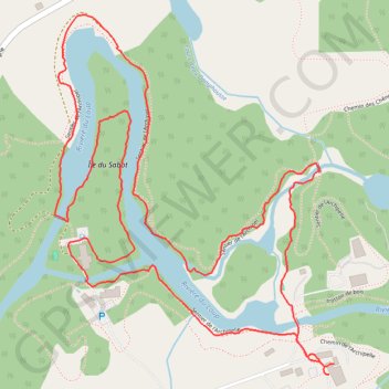
Sentier de l’Archipel
Randonnée en boucle sur le sentier de l’Archipel au bord de la rivière du Loup. #Randonnée #Boucle #Rivière #Forêt #Nature
- Distance: 2.9 mi
- Elevation gain: 115 ft
- Maximum elevation: 522 ft
- Elevation loss: 115 ft
- Minimum elevation: 463 ft
- Moving time: 1 h 30 m
- Moving speed: 1.9 mph
- Maximum speed: 3.2 mph
- Total time: 1 h 43 m
- Global speed: 1.7 mph
- Date: 02/18/2024
Interactive map
GPS track profile
About this GPS track
Name: Sentier de l’Archipel GPS track, route, trail
Coordinates: 46.45132 -73.00889 46.45985 -72.99927
Other GPS tracks
Click on a GPS track to view route, its statistics and profile.