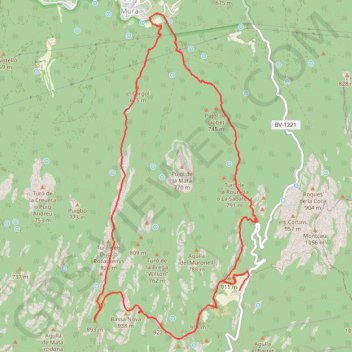
Col d'Estenalles - Mura
Randonnée en boucle depuis Mura. #Randonnée #Boucle #Pyrénées #Montagne #Nature
- Distance: 8.4 mi
- Elevation gain: 2,073 ft
- Maximum elevation: 3,048 ft
- Elevation loss: 2,037 ft
- Minimum elevation: 1,503 ft
- Moving time: 4 h 17 m
- Moving speed: 2.0 mph
- Maximum speed: 4.4 mph
- Total time: 7 h 24 s
- Global speed: 1.2 mph
- Date: 07/08/2012
Interactive map
GPS track profile
About this GPS track
Name: Col d'Estenalles - Mura GPS track, route, trail
Start: Carretera de Talamanca, la Mata, Mura, Bages, Barcelone, Catalogne, Espagne (41.66800 1.99323)
End: GR 5, Mura, Bages, Barcelone, Catalogne, Espagne (41.66999 1.99455)
Coordinates: 41.66251 1.97117 41.69953 1.99601
Other GPS tracks
Click on a GPS track to view route, its statistics and profile.
Southern section — European Divide Trail
France > Auvergne-Rhône-Alpes > Drôme > Valence
Distance: 1,506.1 mi • Elevation gain: 139,026 ft • Maximum elevation: 6,578 ft
1 LUCENA - MONTPELLIER
Distance: 1,842.0 mi • Elevation gain: 96,785 ft • Maximum elevation: 3,438 ft
1 LUCENA - MONTPELLIER
Espagne > Andalousie > Lucena
Distance: 1,842.0 mi • Elevation gain: 96,785 ft • Maximum elevation: 3,438 ft
Stage 26: Valence to Saint-Jean-de-Fos — European Divide Trail
France > Auvergne-Rhône-Alpes > Drôme > Valence
Distance: 1,506.1 mi • Elevation gain: 139,026 ft • Maximum elevation: 6,578 ft
Barcelonne
Espagne > Haut-Ampurdan > Llançà
Barcelonne
Distance: 824.8 mi • Elevation gain: 102,241 ft • Maximum elevation: 5,692 ft
Stage 26: Valence to Saint-Jean-de-Fos — European Divide Trail
France > Auvergne-Rhône-Alpes > Drôme > Valence
Distance: 1,012.7 mi • Elevation gain: 101,184 ft • Maximum elevation: 6,578 ft
OziCE Track Log File- filtered
France > Occitanie > Pyrénées-Orientales > Banyuls-sur-Mer
OziCE Track Log File- filtered
Distance: 907.8 mi • Elevation gain: 118,281 ft • Maximum elevation: 5,715 ft
Monday Afternoon Flight
Espagne > Îles Baléares > Palma > Son Banya
Distance: 391.4 mi • Elevation gain: 87,385 ft • Maximum elevation: 8,478 ft
Santa Susana, Cardedeu, Castellbell i Vilar, Prades, Torto
Espagne > Catalogne > Maresme > Santa Susanna
Distance: 252.4 mi • Elevation gain: 40,023 ft • Maximum elevation: 3,770 ft