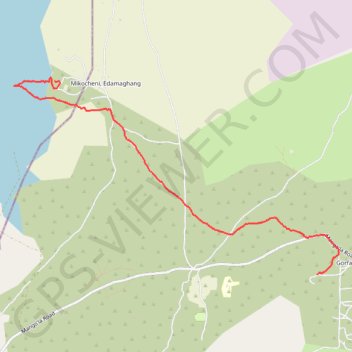
2017-09-19_18-06-51
En aller simple.
- Distance: 5.3 mi
- Elevation gain: 213 ft
- Maximum elevation: 3,678 ft
- Elevation loss: 358 ft
- Minimum elevation: 3,366 ft
- Moving time: 2 h 13 s
- Moving speed: 2.6 mph
- Maximum speed: 5.7 mph
- Total time: 2 h 17 m
- Global speed: 2.3 mph
- Date: 09/19/2017
Interactive map
GPS track profile
About this GPS track
Name: 2017-09-19_18-06-51 GPS track, route, trail
Start: Gorfani, Baray, Karatu, Région d'Arusha, Northern Zone, Tanzanie (-3.50218 35.38738)
Coordinates: -3.50218 35.34415 -3.47420 35.39052