Traversière Mont Humbold
- Distance: 17.6 mi
- Elevation gain: 5,102 ft
- Maximum elevation: 5,207 ft
- Elevation loss: 6,660 ft
- Minimum elevation: 7 ft
Interactive map
GPS track profile
About this GPS track
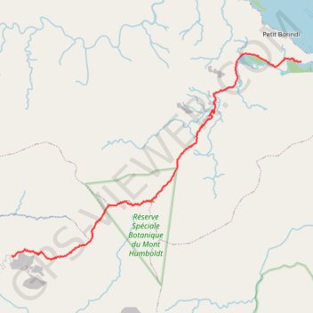
Name: Traversière Mont Humbold GPS track, route, trail
Start: Piste Mine Gallieni, Païta, Province Sud, Nouvelle-Calédonie, France (-21.90766 166.34746)
Coordinates: -21.90941 166.34746 -21.80662 166.50320
Other GPS tracks
Click on a GPS track to view route, its statistics and profile.
Traversière Mont Humbold
France > Province Sud > Païta
Randonnée pédestre. En aller simple. #Randonnée
Distance: 17.7 mi • Elevation gain: 5,157 ft • Maximum elevation: 5,207 ft