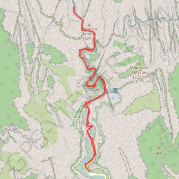
The Narrows
Hike along Virgin River to The Narrows from Temple of Sinawava via Riverside Walk, The Narrows Day Hike Section, Mystery Canyon Falls, 200' Waterfall, House Rock and Floating Rock in the Zion National Park. #Hile #Canyon #River #Rock #Nature #Park #Falls #Zion
- Distance: 7.0 mi
- Elevation gain: 5,180 ft
- Maximum elevation: 5,194 ft
- Elevation loss: 5,174 ft
- Minimum elevation: 4,429 ft
Interactive map
GPS track profile
About this GPS track
Name: The Narrows GPS track, route, trail
Coordinates: 37.28527 -112.95142 37.31388 -112.94439
Topography: Washington County topographic map
Other GPS tracks
Click on a GPS track to view route, its statistics and profile.