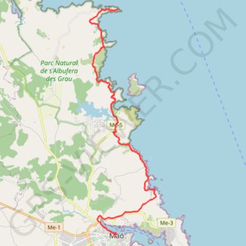
Mahon - Phare de Favaritx
Randonnée depuis Maó. #Randonnée
- Distance: 13.9 mi
- Elevation gain: 1,526 ft
- Maximum elevation: 210 ft
- Elevation loss: 1,634 ft
- Minimum elevation: -3 ft
- Moving time: 4 h 27 m
- Moving speed: 3.1 mph
- Maximum speed: 38.6 mph
- Total time: 6 h 50 m
- Global speed: 2.0 mph
- Date: 07/21/2014
Interactive map
GPS track profile
About this GPS track
Name: Mahon - Phare de Favaritx GPS track, route, trail
Start: 5, Plaça del Carme, Port-Mahon, Minorque, Îles Baléares, 07701, Espagne (39.88870 4.26577)
End: Cf-1, Port-Mahon, Minorque, Îles Baléares, Espagne (39.99707 4.26701)
Coordinates: 39.88869 4.24971 39.99725 4.29112
Other GPS tracks
Click on a GPS track to view route, its statistics and profile.
Southern section — European Divide Trail
France > Auvergne-Rhône-Alpes > Drôme > Valence
Distance: 1,506.1 mi • Elevation gain: 139,026 ft • Maximum elevation: 6,578 ft
1 LUCENA - MONTPELLIER
Distance: 1,842.0 mi • Elevation gain: 96,785 ft • Maximum elevation: 3,438 ft
1 LUCENA - MONTPELLIER
Espagne > Andalousie > Lucena
Distance: 1,842.0 mi • Elevation gain: 96,785 ft • Maximum elevation: 3,438 ft
TMCS 85 km
Espagne > Îles Baléares > Minorque > es Castell > Santa Anna
Distance: 52.6 mi • Elevation gain: 3,950 ft • Maximum elevation: 266 ft
Stage 26: Valence to Saint-Jean-de-Fos — European Divide Trail
France > Auvergne-Rhône-Alpes > Drôme > Valence
Distance: 1,506.1 mi • Elevation gain: 139,026 ft • Maximum elevation: 6,578 ft
PARCOURS-77km-IBP210-hiking
Espagne > Îles Baléares > Minorque > Ferreries > Cala Galdana
Parcours créé avec gpstraces.net. Indice IBP de cette trace : 210
Distance: 47.8 mi • Elevation gain: 4,216 ft • Maximum elevation: 1,125 ft
PARCOURS-98km-IBP256-hiking
Espagne > Îles Baléares > Minorque > Port-Mahon > es Grau
Parcours créé avec gpstraces.net. Indice IBP de cette trace : 256
Distance: 60.4 mi • Elevation gain: 4,757 ft • Maximum elevation: 709 ft
Stage 26: Valence to Saint-Jean-de-Fos — European Divide Trail
France > Auvergne-Rhône-Alpes > Drôme > Valence
Distance: 1,012.7 mi • Elevation gain: 101,184 ft • Maximum elevation: 6,578 ft