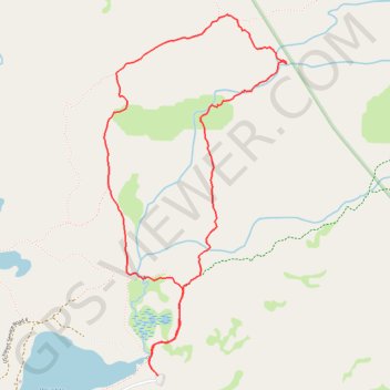
Wrights Lake and Enchanted Pools Loop
Loop hike from Wrights Lake via Twin Lakes Trail, Enchanted Pools, Tyler Lake Trail, Rockbound Trail and Old Corral Loop Trail in the Eldorado National Forest and the Desolation Wilderness. #Hike #Loop #Lake #Nature #Forest #Mountain #River #Falls #Wilderness
- Distance: 4.0 mi
- Elevation gain: 449 ft
- Maximum elevation: 7,313 ft
- Elevation loss: 446 ft
- Minimum elevation: 6,962 ft
- Moving time: 2 h 57 m
- Moving speed: 1.4 mph
- Maximum speed: 3.7 mph
- Total time: 3 h 15 m
- Global speed: 1.2 mph
Interactive map
GPS track profile
About this GPS track
Name: Wrights Lake and Enchanted Pools Loop GPS track, route, trail
Start: Service road, El Dorado County, California, United States (38.84961 -120.22570)
End: Service road, El Dorado County, California, United States (38.84959 -120.22562)
Coordinates: 38.84959 -120.22946 38.86938 -120.21664
Topography: El Dorado County topographic map, elevation, terrain
Other GPS tracks
Click on a GPS track to view its route, statistics and profile.
Chester - Walker
États-Unis d'Amérique > Californie > Plumas County > Chester
Vélo. En aller simple entre Chester et Walker. #Vélo
Distance: 238.5 mi • Elevation gain: 19,974 ft • Maximum elevation: 8,337 ft