Import a GPX file

Dun Aengus

Randonnée pédestre. En boucle. #Randonnée #Boucle

  • Distance: 13.6 mi
  • Elevation gain: 1,450 ft
  • Maximum elevation: 394 ft
  • Elevation loss: 1,440 ft
  • Minimum elevation: -3 ft
  • Moving time: 5 h 12 m
  • Moving speed: 2.6 mph
  • Maximum speed: 4.7 mph
  • Total time: 7 h 16 m
  • Global speed: 1.9 mph
  • Date: 07/08/2010

Interactive map

GPS track profile

About this GPS track
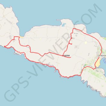
Other GPS tracks

Click on a GPS track to view route, its statistics and profile.

Trace IRELAND

Irlande > Comté de Wexford

Distance: 936.2 mi • Elevation gain: 43,829 ft • Maximum elevation: 1,719 ft

RT5-1 Rosslare - Kinsale

Irlande > Comté de Wexford

Distance: 1,777.3 mi • Elevation gain: 89,833 ft • Maximum elevation: 1,378 ft

RT5-1 Rosslare - Kinsale

Irlande > Comté de Wexford

Distance: 2,402.9 mi • Elevation gain: 118,488 ft • Maximum elevation: 1,719 ft

Tour de l'Irlande : Cork - Waterford

Irlande > Comté de Cork > Cork

#Irlande #Boucle

Distance: 706.6 mi • Elevation gain: 27,644 ft • Maximum elevation: 978 ft

Black Fort

Irlande > County Galway

Randonnée pédestre. En boucle. #Randonnée #Boucle

Distance: 11.9 mi • Elevation gain: 1,152 ft • Maximum elevation: 299 ft