Uinta-Wasatch-Cache National Forest
- Distance: 5.5 mi
- Elevation gain: 207 ft
- Maximum elevation: 5,722 ft
- Elevation loss: 1,204 ft
- Minimum elevation: 4,665 ft
- Moving time: 36 m 41 s
- Moving speed: 9.0 mph
- Maximum speed: 27.7 mph
- Total time: 49 m 1 s
- Global speed: 6.8 mph
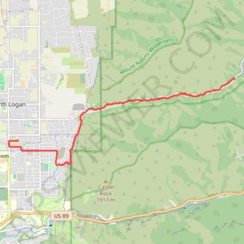
Interactive map
GPS track profile
About this GPS track
Name: Uinta-Wasatch-Cache National Forest GPS track, route, trail
Start: Green Canyon Trail, Cache County, Utah, United States (41.77527 -111.73314)
End: 1300, 1600 North, North Logan, Cache County, Utah, 84341, United States (41.76096 -111.80154)
Coordinates: 41.75493 -111.80432 41.77541 -111.73314
Topography: Cache County topographic map, elevation, terrain
Other GPS tracks
Click on a GPS track to view its route, statistics and profile.
Bonneville Shoreline Trail
United States > Utah > Cache County > Logan
cycling, mtb
Distance: 5.8 mi • Elevation gain: 653 ft • Maximum elevation: 5,098 ft
Green Canyon Trail
United States > Utah > Cache County
Distance: 6.9 mi • Elevation gain: 814 ft • Maximum elevation: 6,680 ft