De Pérouse à Umbertide
Randonnée entre Perugia et Umbertide. #Randonnée
- Distance: 18.7 mi
- Elevation gain: 2,051 ft
- Maximum elevation: 1,824 ft
- Elevation loss: 2,802 ft
- Minimum elevation: 774 ft
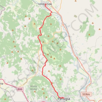
Interactive map
GPS track profile
About this GPS track
Name: De Pérouse à Umbertide GPS track, route, trail
End: Piazza Carlo Marx, Umbertide, Perugia, Ombrie, 06019, Italie (43.30577 12.33657)
Coordinates: 43.11276 12.31649 43.30577 12.38964
Other GPS tracks
Click on a GPS track to view route, its statistics and profile.
Tour d'Europe
France > Bretagne > Finistère > Concarneau > Landan Creis
Distance: 4,432.2 mi • Elevation gain: 146,335 ft • Maximum elevation: 7,982 ft
1 LUCENA - MONTPELLIER
Distance: 1,842.0 mi • Elevation gain: 96,785 ft • Maximum elevation: 3,438 ft
1 LUCENA - MONTPELLIER
Espagne > Andalousie > Lucena
Distance: 1,842.0 mi • Elevation gain: 96,785 ft • Maximum elevation: 3,438 ft
Percorso selezionato
Italie > Lombardie > Côme > Côme
Percorso calcolato con http://www.bicitalia.org/it/routing-gpx
Distance: 959.4 mi • Elevation gain: 58,894 ft • Maximum elevation: 3,392 ft
De Giromagny à Sofia
France > Bourgogne-Franche-Comté > Territoire-de-Belfort > Giromagny
Distance: 1,165.7 mi • Elevation gain: 39,724 ft • Maximum elevation: 3,458 ft