Machame - J7
Randonnée pédestre. En aller simple. #Randonnée
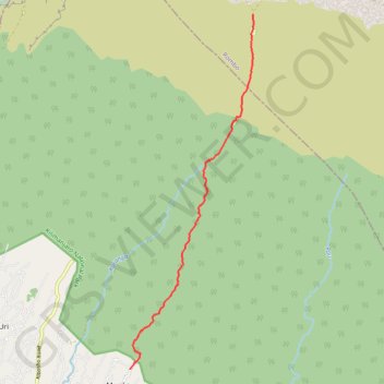
- Distance: 8.2 mi
- Elevation gain: 0 ft
- Maximum elevation: 12,841 ft
- Elevation loss: 7,602 ft
- Minimum elevation: 5,240 ft
Interactive map
GPS track profile
About this GPS track
Name: Machame - J7 GPS track, route, trail
Start: Millenium Camp, Scree Slope, Rombo, Kilimandjaro, Northern Zone, Tanzanie (-3.12813 37.37219)
Coordinates: -3.22166 37.33976 -3.12813 37.37242
Other GPS tracks
Click on a GPS track to view route, its statistics and profile.
Kilimanjaro - Voie Lemosho 9 jours
Randonnée pédestre. #Randonnée
Distance: 31.3 mi • Elevation gain: 11,667 ft • Maximum elevation: 19,281 ft
Machame - J6
Randonnée pédestre. #Randonnée
Distance: 8.4 mi • Elevation gain: 4,012 ft • Maximum elevation: 19,262 ft