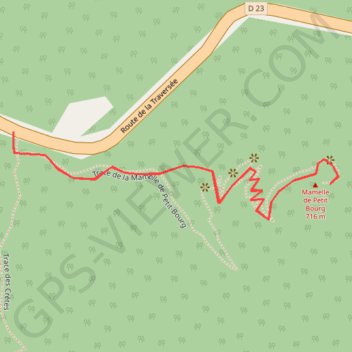
Trace Mamelle de Petit-Bourg
🌍 Ouvrir dans Google Maps :
https://www.google.com/maps/d/embed?mid=1VJ6s4u13Cn0OaTEAOgdmNOh9tNxCCnno
🌍 Ouvrir dans Google Earth :
https://earth.google.com/web/data=MikKJwolCiExVko2czR1MTNDbjBPYVRFQU9nZG1OT2g5dE54Q0Nubm8gAg
- Distance: 1.2 mi
- Elevation gain: 564 ft
- Maximum elevation: 2,228 ft
- Elevation loss: 564 ft
- Minimum elevation: 1,804 ft
Interactive map
GPS track profile
About this GPS track
Name: Trace Mamelle de Petit-Bourg GPS track, route, trail
Start: Route de la Traversée, Petit-Bourg, Basse-Terre, Guadeloupe, 97170, France (16.17838 -61.73183)
End: Route de la Traversée, Petit-Bourg, Basse-Terre, Guadeloupe, 97170, France (16.17838 -61.73183)
Coordinates: 16.17705 -61.73183 16.17838 -61.72670