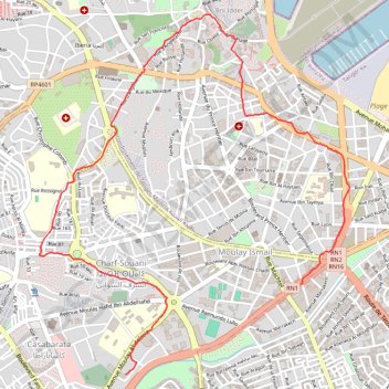
T2020-06-10-13-45
- Distance: 3.9 mi
- Elevation gain: 374 ft
- Maximum elevation: 256 ft
- Elevation loss: 358 ft
- Minimum elevation: 26 ft
- Moving time: 1 h 28 m
- Moving speed: 2.6 mph
- Maximum speed: 6.6 mph
- Total time: 1 h 31 m
- Global speed: 2.6 mph
- Date: 06/10/2020
Interactive map
GPS track profile
About this GPS track
Name: T2020-06-10-13-45 GPS track, route, trail
Coordinates: 35.76315 -5.82449 35.78430 -5.80199
Other GPS tracks
Click on a GPS track to view route, its statistics and profile.
Maroc en boucle depuis Tanger
Maroc > pachalik de Tanger > Tanger
Distance: 1,882.0 mi • Elevation gain: 89,413 ft • Maximum elevation: 7,549 ft
T2020-07-14-22-41
Maroc > pachalik de Tanger > Tanger > Bni Idder
Distance: 2.2 mi • Elevation gain: 89 ft • Maximum elevation: 36 ft