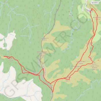
Leuneta y Azketa circular desde Arano
- Distance: 10.6 mi
- Elevation gain: 2,874 ft
- Maximum elevation: 2,838 ft
- Elevation loss: 2,874 ft
- Minimum elevation: 1,480 ft
- Moving time: 5 h 18 m
- Moving speed: 2.0 mph
- Maximum speed: 4.4 mph
- Total time: 6 h 9 m
- Global speed: 1.7 mph
- Date: 01/06/2022
Interactive map
GPS track profile
About this GPS track
Name: Leuneta y Azketa circular desde Arano GPS track, route, trail
Start: Goiko Herria, Latse, Goiko Herri, Arano, Larraun-Leitzaldea, 31754, Espagne (43.19880 -1.89436)
End: Goiko Herria, Latse, Goiko Herri, Arano, Larraun-Leitzaldea, 31754, Espagne (43.19877 -1.89438)
Coordinates: 43.16564 -1.94342 43.20047 -1.89027
Other GPS tracks
Click on a GPS track to view route, its statistics and profile.
Camino del Norte - Compostelle
Espagne > Pays basque autonome > Basse-Bidassoa > Irun
Randonnée littorale le long de la côte Atlantique entre Irun et Muxia sur le chemin de Saint-Jacques-de-Compostelle. #Randonnée #Compostelle #Mer #Océan #Atlantique #Nature
Distance: 560.3 mi • Elevation gain: 59,094 ft • Maximum elevation: 2,316 ft
Southern section — European Divide Trail
France > Auvergne-Rhône-Alpes > Drôme > Valence
Distance: 1,506.1 mi • Elevation gain: 139,026 ft • Maximum elevation: 6,578 ft
EuroVelo 1 (Spain)
Espagne > Andalousie > Côte occidentale > Ayamonte
Distance: 842.4 mi • Elevation gain: 47,858 ft • Maximum elevation: 4,331 ft
Eurovelo 01 Spain + Portugal
France > Nouvelle-Aquitaine > Pyrénées-Atlantiques > Hendaye
Distance: 1,930.7 mi • Elevation gain: 100,367 ft • Maximum elevation: 4,931 ft
Chemin de Saint-Jacques-de-Compostelle de Saint-Germain-des-Prés à Cap Finisterre
France > Centre-Val de Loire > Loiret > Saint-Germain-des-Prés > Montantaume
Randonnée. En aller simple entre Saint-Germain-des-Prés et Fisterra. #Randonnée #Compostelle
Distance: 1,358.7 mi • Elevation gain: 141,211 ft • Maximum elevation: 5,276 ft
Tour d'Europe
France > Bretagne > Finistère > Concarneau > Landan Creis
Distance: 4,432.2 mi • Elevation gain: 146,335 ft • Maximum elevation: 7,982 ft
Transpyrenees 2021- SPAIN
Espagne > Catalogne > Haut-Ampurdan > Llançà
Distance: 642.7 mi • Elevation gain: 96,450 ft • Maximum elevation: 7,913 ft
Buitrago -Hendaye Gravel 438km 4440D+
Espagne > Communauté de Madrid > Buitrago del Lozoya
Distance: 272.4 mi • Elevation gain: 18,950 ft • Maximum elevation: 4,787 ft
1 LUCENA - MONTPELLIER
Distance: 1,842.0 mi • Elevation gain: 96,785 ft • Maximum elevation: 3,438 ft
1 LUCENA - MONTPELLIER
Espagne > Andalousie > Lucena
Distance: 1,842.0 mi • Elevation gain: 96,785 ft • Maximum elevation: 3,438 ft
Camino del Norte
Espagne > Pays basque autonome > Basse-Bidassoa > Irun
ce tracé est l'un des parcours du Camino del Norte. Environ 30 jours pour arriver à St Jacques de Compostelle, et 35 jours pour aller au bout, ou plus si on veut prendre son temps ;)
Distance: 560.3 mi • Elevation gain: 58,980 ft • Maximum elevation: 2,316 ft
Camino del Norte - Compostelle
Espagne > Pays basque autonome > Basse-Bidassoa > Irun
Distance: 560.3 mi • Elevation gain: 58,970 ft • Maximum elevation: 2,316 ft
Track liberty-2023-11-18T06:38:38.493Z
France > Nouvelle-Aquitaine > Pyrénées-Atlantiques > Saint-Jean-de-Luz
Distance: 804.5 mi • Elevation gain: 86,877 ft • Maximum elevation: 5,190 ft
NORTE POR OVIEDO
Espagne > Pays basque autonome > Basse-Bidassoa > Irun
Distance: 500.0 mi • Elevation gain: 60,741 ft • Maximum elevation: 2,329 ft
Mandoegi y Urepel desde Goizueta
Espagne > Larraun-Leitzaldea > Goizueta
Distance: 9.2 mi • Elevation gain: 3,655 ft • Maximum elevation: 3,386 ft
Stage 26: Valence to Saint-Jean-de-Fos — European Divide Trail
France > Auvergne-Rhône-Alpes > Drôme > Valence
Distance: 1,506.1 mi • Elevation gain: 139,026 ft • Maximum elevation: 6,578 ft
EuroVelo 1 (Spain)
Espagne > Andalousie > Côte occidentale > Ayamonte > Pozo del Camino > Fotea
Distance: 838.7 mi • Elevation gain: 44,754 ft • Maximum elevation: 4,331 ft
(tous)_saint_Jacques_de_Compostelle_1600Km
France > Auvergne-Rhône-Alpes > Haute-Loire > Le Puy-en-Velay
Distance: 1,000.5 mi • Elevation gain: 97,608 ft • Maximum elevation: 4,928 ft
ACTIVE LOG: 13 AVR 2009 08:36
Espagne > Castille-et-León > Burgos
Distance: 150.7 mi • Elevation gain: 6,932 ft • Maximum elevation: 3,228 ft
Stage 26: Valence to Saint-Jean-de-Fos — European Divide Trail
France > Auvergne-Rhône-Alpes > Drôme > Valence
Distance: 1,012.7 mi • Elevation gain: 101,184 ft • Maximum elevation: 6,578 ft
De Villeneuve-sur-Lot à Guimarães
France > Nouvelle-Aquitaine > Lot-et-Garonne > Villeneuve-sur-Lot
Distance: 1,257.8 mi • Elevation gain: 72,575 ft • Maximum elevation: 4,393 ft
18/10/2020 12:05:36
Espagne > Pays basque autonome > Basse-Bidassoa > Fontarrabie
18/10/2020 12:05:36
Distance: 1,097.2 mi • Elevation gain: 107,316 ft • Maximum elevation: 5,272 ft