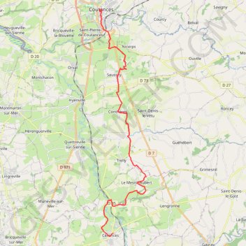
Le chemin aux Anglais - Coutances à Cérences
Randonnée entre Coutances et Cérences. #Randonnée
- Distance: 14.6 mi
- Elevation gain: 1,266 ft
- Maximum elevation: 315 ft
- Elevation loss: 1,407 ft
- Minimum elevation: 52 ft
Interactive map
GPS track profile
About this GPS track
Name: Le chemin aux Anglais - Coutances à Cérences GPS track, route, trail
Coordinates: 48.91456 -1.44697 49.04773 -1.40522
Other GPS tracks
Click on a GPS track to view route, its statistics and profile.
GR 223 Tour du Cotentin (2021)
France > Normandie > Eure > Berville-sur-Mer
Randonnée en Normandie sur le GR 223 autour du Cotentin à travers l'Eure, le Calvados et la Manche de Berville-sur-Mer au Mont-Saint-Michel.
Distance: 404.3 mi • Elevation gain: 21,932 ft • Maximum elevation: 489 ft
Tour d'Europe
France > Bretagne > Finistère > Concarneau > Landan Creis
Distance: 4,432.2 mi • Elevation gain: 146,335 ft • Maximum elevation: 7,982 ft
Sentier Cotentin - Cherbourg vers Mont-Saint-Michel
France > Normandie > Manche > La Hague > Urville-Nacqueville > La Rivière
Distance: 144.0 mi • Elevation gain: 8,478 ft • Maximum elevation: 420 ft
HexaTrekGPX
France > Nouvelle-Aquitaine > Pyrénées-Atlantiques > Hendaye
Distance: 1,670.4 mi • Elevation gain: 452,047 ft • Maximum elevation: 9,675 ft
4 Hauteville Vierville
France > Normandie > Manche > Hauteville-sur-Mer
Aller de Hauteville à Vierville le 08/06/2024 à 8H00
Distance: 51.3 mi • Elevation gain: 2,388 ft • Maximum elevation: 463 ft
1 Hautteville Isigny
France > Normandie > Manche > Hauteville-sur-Mer
Parcours initial sans la section sur la N174 Hautteville Isigny le 07/06/2024 à 8H00
Distance: 44.1 mi • Elevation gain: 1,916 ft • Maximum elevation: 476 ft
5 Vierville Hauteville
France > Normandie > Calvados > Vierville-sur-Mer
Parcours initial Vierville Hauteville le 08/06/2024 à 15h
Distance: 50.3 mi • Elevation gain: 2,044 ft • Maximum elevation: 551 ft
3 Sainte-Mère Hauteville
France > Normandie > Manche > Sainte-Mère-Église > Richedoux
Parcours initial Sainte-Mère Hauteville le 07/06/2024 à 16H30
Distance: 51.1 mi • Elevation gain: 1,253 ft • Maximum elevation: 180 ft
GR223 - Cherbourg à Coutances
France > Normandie > Manche > Cherbourg-en-Cotentin
Randonnée entre Cherbourg-Octeville et Coutances. #Randonnée
Distance: 125.1 mi • Elevation gain: 6,909 ft • Maximum elevation: 453 ft
Eurovelo 6
France > Pays de la Loire > Loire-Atlantique > Saint-Brevin-les-Pins
Distance: 2,815.0 mi • Elevation gain: 59,196 ft • Maximum elevation: 2,808 ft
RAF 2022 / 2600 n1 News
France > Hauts-de-France > Pas-de-Calais > Le Touquet-Paris-Plage
Distance: 1,612.3 mi • Elevation gain: 130,331 ft • Maximum elevation: 9,075 ft
Accès secours Hôpital
France > Normandie > Manche > Saint-Pierre-de-Coutances
Accès secours Hôpital Coutances
Distance: 2.0 mi • Elevation gain: 105 ft • Maximum elevation: 318 ft
Treport Mont saint Michel
France > Normandie > Seine-Maritime > Le Tréport
Vélo. En aller simple entre Le Tréport et Pontorson. #Vélo
Distance: 229.9 mi • Elevation gain: 11,132 ft • Maximum elevation: 938 ft
Itinéraire de Nemours à Nemours
France > Centre-Val de Loire > Loiret > Bromeilles > Bainvilliers
Distance: 979.5 mi • Elevation gain: 28,005 ft • Maximum elevation: 781 ft
TM2024 ET2 Barneville- Sartilly V1-17625469
France > Normandie > Manche > Barneville-Carteret > Le Dessous du Bourg
Distance: 106.1 mi • Elevation gain: 5,656 ft • Maximum elevation: 427 ft
Carentan (50500), Carentan-les-Marais, Manche, Normandie, France - Caen (14000), Calvados, Normandie, France
France > Normandie > Manche > Carentan-les-Marais
Distance: 229.0 mi • Elevation gain: 11,299 ft • Maximum elevation: 863 ft
Hexatrek_Parcours_Complet_NOBO
France > Nouvelle-Aquitaine > Pyrénées-Atlantiques > Hendaye
Distance: 1,669.6 mi • Elevation gain: 454,554 ft • Maximum elevation: 9,259 ft
TM2024 ET4 Pont Hébert- St Pierre de Coutances-17783107
France > Normandie > Manche > Pont-Hébert > La Bessinière
Distance: 62.1 mi • Elevation gain: 4,452 ft • Maximum elevation: 554 ft
Euro 6
France > Pays de la Loire > Loire-Atlantique > Saint-Brevin-les-Pins
Distance: 2,634.6 mi • Elevation gain: 52,064 ft • Maximum elevation: 2,808 ft
1 - etape-3-tdn-2024-parcours (1)
France > Normandie > Manche > Coutances
Etape 3 16 mars 2024
Distance: 85.2 mi • Elevation gain: 6,007 ft • Maximum elevation: 515 ft
Track-Saint Jean de Luz
Belgique > Hainaut > Ath > Lessines
Distance: 740.9 mi • Elevation gain: 31,145 ft • Maximum elevation: 1,594 ft
Track-Saint de Luz retour
France > Nouvelle-Aquitaine > Pyrénées-Atlantiques > Saint-Jean-de-Luz
Distance: 704.3 mi • Elevation gain: 22,598 ft • Maximum elevation: 843 ft
Voie 2ème DB - T1
France > Normandie > Manche > Saint-Martin-de-Varreville > Hameau Mottet
Distance: 83.5 mi • Elevation gain: 3,986 ft • Maximum elevation: 472 ft
1 - tm2024_et4_pont_hebert_st_pierre_coutances_v3-17955504-1702744686-581
France > Normandie > Manche > Pont-Hébert
Etape 4
Distance: 61.4 mi • Elevation gain: 4,505 ft • Maximum elevation: 554 ft
Hexatrek_Parcours_Complet_SOBO
Allemagne > Rhénanie-Palatinat > Arrondissement de la Route-du-Vin-du-Sud > Schweigen-Rechtenbach
Distance: 1,670.4 mi • Elevation gain: 454,117 ft • Maximum elevation: 9,278 ft
TM2024 ET4 Hébécrevon - St Pierre Coutances-17288219
France > Normandie > Manche > Hébécrevon > La Cauvinière
Distance: 61.6 mi • Elevation gain: 4,531 ft • Maximum elevation: 554 ft
TM2024 ET2 Barneville- Sartilly V1-17625469
France > Normandie > Manche > Barneville-Carteret > Le Dessous du Bourg
Distance: 106.1 mi • Elevation gain: 5,656 ft • Maximum elevation: 427 ft
TM2023 Etape 4 La Haye - Isigny le Buat-15581218
France > Normandie > Manche > La Haye-du-Puits > Le Clos Versailles
Distance: 105.7 mi • Elevation gain: 7,116 ft • Maximum elevation: 735 ft
TM2024 ET2 Barneville - Sartilly V2-17230687
France > Normandie > Manche > Barneville-Carteret > Le Dessous du Bourg
Distance: 98.3 mi • Elevation gain: 4,977 ft • Maximum elevation: 427 ft
HexaTrekGPX
France > Nouvelle-Aquitaine > Pyrénées-Atlantiques > Hendaye
Distance: 1,670.4 mi • Elevation gain: 452,047 ft • Maximum elevation: 9,675 ft
TM2024 ET2 Barneville - Sartilly V2-17230687
France > Normandie > Manche > Barneville-Carteret > Le Dessous du Bourg
Distance: 107.7 mi • Elevation gain: 5,279 ft • Maximum elevation: 427 ft
Voie 2ème DB : St-Martin-de-Varreville - Avranches
France > Normandie > Manche > Saint-Martin-de-Varreville > Hameau Mottet
Distance: 83.4 mi • Elevation gain: 3,848 ft • Maximum elevation: 472 ft
TM2024 ET2 Barneville - Sartilly V2-17230687
France > Normandie > Manche > Barneville-Carteret > Le Dessous du Bourg
Distance: 105.9 mi • Elevation gain: 5,098 ft • Maximum elevation: 427 ft
A pied - Les Vallons de Cérences
France > Normandie > Manche > Cérences > L'Hôtel au Roy
Point de départ conseillé : Gîte - Halte de randonnée, rue du bocage, Cérences. Cette randonnée vous plonge au cœur du bocage et des hameaux de Cérences. Les magnifiques chemins creux vous guideront du val de la Sienne à celui de l’Airou. Une belle déconnexion « nature ».
Distance: 12.8 mi • Elevation gain: 1,024 ft • Maximum elevation: 348 ft
TM2024 ET2 Barneville - Sartilly V2-17230687
France > Normandie > Manche > Barneville-Carteret > Le Dessous du Bourg
Distance: 99.3 mi • Elevation gain: 4,987 ft • Maximum elevation: 427 ft
TM2024 ET2 Barneville - Sartilly V2-17230687
France > Normandie > Manche > Barneville-Carteret > Le Dessous du Bourg
Distance: 99.3 mi • Elevation gain: 4,987 ft • Maximum elevation: 427 ft
TM2023 Etape 3 SARTILLY - LA HAYE
France > Normandie > Manche > Sartilly-Baie-Bocage
Distance: 61.9 mi • Elevation gain: 2,549 ft • Maximum elevation: 433 ft