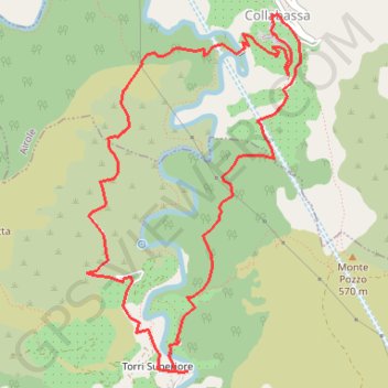
Torri collabassa
Interactive map
GPS track profile
About this GPS track
Name: Torri collabassa GPS track, route, trail
Start: Torri Superiore, Torri Inferiore, Vintimille, Imperia, Ligurie, 18030, Italie (43.83999 7.55385)
End: Torri Superiore, Torri Inferiore, Vintimille, Imperia, Ligurie, 18030, Italie (43.83991 7.55364)
Coordinates: 43.83988 7.54533 43.86178 7.56338
Other GPS tracks
Click on a GPS track to view route, its statistics and profile.
HexaTrekGPX
France > Nouvelle-Aquitaine > Pyrénées-Atlantiques > Hendaye
Distance: 1,670.4 mi • Elevation gain: 452,047 ft • Maximum elevation: 9,675 ft
TET-FRANCE-Section04- 20190827
Italie > Ligurie > Imperia > Olivetta > Olivetta San Michele
Distance: 640.4 mi • Elevation gain: 91,089 ft • Maximum elevation: 6,152 ft
Eurovelo 6
France > Pays de la Loire > Loire-Atlantique > Saint-Brevin-les-Pins
Distance: 2,815.0 mi • Elevation gain: 59,196 ft • Maximum elevation: 2,808 ft
Tour d'Europe
France > Bretagne > Finistère > Concarneau > Landan Creis
Distance: 4,432.2 mi • Elevation gain: 146,335 ft • Maximum elevation: 7,982 ft
1 LUCENA - MONTPELLIER
Distance: 1,842.0 mi • Elevation gain: 96,785 ft • Maximum elevation: 3,438 ft
1 LUCENA - MONTPELLIER
Espagne > Andalousie > Lucena
Distance: 1,842.0 mi • Elevation gain: 96,785 ft • Maximum elevation: 3,438 ft
De Giromagny à Sofia
France > Bourgogne-Franche-Comté > Territoire-de-Belfort > Giromagny
Distance: 1,165.7 mi • Elevation gain: 39,724 ft • Maximum elevation: 3,458 ft
Hexatrek_Parcours_Complet_NOBO
France > Nouvelle-Aquitaine > Pyrénées-Atlantiques > Hendaye
Distance: 1,669.6 mi • Elevation gain: 454,554 ft • Maximum elevation: 9,259 ft
Circuit de gravel de ta life
France > Provence-Alpes-Côte d'Azur > Alpes-Maritimes > Nice
Distance: 161.2 mi • Elevation gain: 41,312 ft • Maximum elevation: 7,359 ft
Euro 6
France > Pays de la Loire > Loire-Atlantique > Saint-Brevin-les-Pins
Distance: 2,634.6 mi • Elevation gain: 52,064 ft • Maximum elevation: 2,808 ft
Traversée Col de Tende - Vintimille
Italie > Piémont > Coni > Limone Piemonte
VTT. En aller simple entre Tende et Ventimiglia. Alpes maritimes et ligures. #VTT #Alpes #MontagneMaritimes #Ligures #Alpes #Montagne #Mercantour #Argentera #Nature
Distance: 68.3 mi • Elevation gain: 15,354 ft • Maximum elevation: 7,562 ft
Hexatrek_Parcours_Complet_SOBO
Allemagne > Rhénanie-Palatinat > Arrondissement de la Route-du-Vin-du-Sud > Schweigen-Rechtenbach
Distance: 1,670.4 mi • Elevation gain: 454,117 ft • Maximum elevation: 9,278 ft
Limone - Ventimiglia
Italie > Piémont > Coni > Limone Piemonte
Distance: 66.1 mi • Elevation gain: 12,441 ft • Maximum elevation: 7,356 ft
HexaTrekGPX
France > Nouvelle-Aquitaine > Pyrénées-Atlantiques > Hendaye
Distance: 1,670.4 mi • Elevation gain: 452,047 ft • Maximum elevation: 9,675 ft
Etape2
France > Provence-Alpes-Côte d'Azur > Alpes-de-Haute-Provence > Jausiers
Distance: 161.4 mi • Elevation gain: 33,691 ft • Maximum elevation: 8,691 ft
PT23DS2 Lörrach → Cadaqués
Germany > Baden-Württemberg > Landkreis Lörrach > Lörrach
Distance: 652.9 mi • Elevation gain: 43,077 ft • Maximum elevation: 4,938 ft
Tour de Suisse août V2
France > Provence-Alpes-Côte d'Azur > Bouches-du-Rhône > Marseille
Distance: 1,606.1 mi • Elevation gain: 168,038 ft • Maximum elevation: 8,130 ft
Itinéraire de Castries à Via Enrico Fermi, 1, 10028 Trofarello TO, Italie
France > Occitanie > Hérault > Castries
Distance: 280.9 mi • Elevation gain: 21,204 ft • Maximum elevation: 6,083 ft