Pointe de Capelinhos, Açores
Interactive map
GPS track profile
About this GPS track
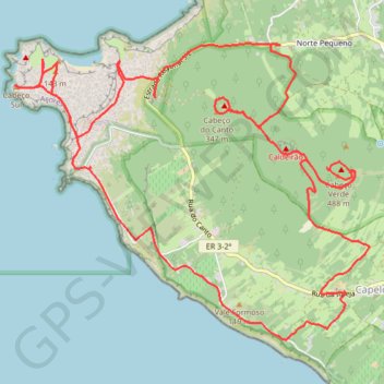
Name: Pointe de Capelinhos, Açores GPS track, route, trail
Start: Rua da Igreja, Capelo, Horta, Açores, 9900-304, Portugal (38.58201 -28.79745)
End: 79, Rua da Igreja, Capelo, Horta, Açores, 9900-302, Portugal (38.58205 -28.79733)
Coordinates: 38.57791 -28.83370 38.60347 -28.79457
Other GPS tracks
Click on a GPS track to view route, its statistics and profile.
Capelinhos
Randonnée pédestre. #Randonnée
Distance: 6.6 mi • Elevation gain: 1,637 ft • Maximum elevation: 463 ft