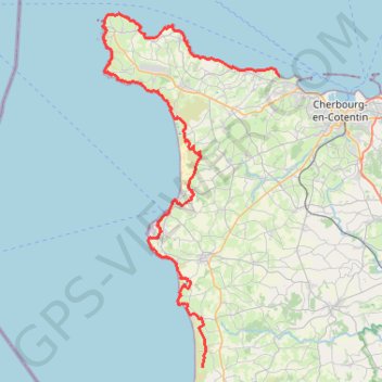
Rando cap de la Hague
Randonnée entre Urville-Nacqueville et Baubigny. #Randonnée
- Distance: 49.6 mi
- Elevation gain: 4,521 ft
- Maximum elevation: 427 ft
- Elevation loss: 4,488 ft
- Minimum elevation: -3 ft
Interactive map
GPS track profile
About this GPS track
Name: Rando cap de la Hague GPS track, route, trail
Coordinates: 49.41595 -1.94812 49.72696 -1.70794
Other GPS tracks
Click on a GPS track to view route, its statistics and profile.
GR 223 Tour du Cotentin (2021)
France > Normandie > Eure > Berville-sur-Mer
Randonnée en Normandie sur le GR 223 autour du Cotentin à travers l'Eure, le Calvados et la Manche de Berville-sur-Mer au Mont-Saint-Michel.
Distance: 404.3 mi • Elevation gain: 21,932 ft • Maximum elevation: 489 ft
Etape 2 du Raid de l'Archange
France > Normandie > Manche > Carteret > Le Valnotte
De Carteret à Lestre
Distance: 49.6 mi • Elevation gain: 2,070 ft • Maximum elevation: 374 ft
Etape 1 du Raid de l'Archange
France > Normandie > Manche > La Hague > Beaumont-Hague > Le Hameau Sauvage
De La Hague à Carteret
Distance: 45.5 mi • Elevation gain: 5,810 ft • Maximum elevation: 571 ft
Sentier Cotentin - Cherbourg vers Mont-Saint-Michel
France > Normandie > Manche > La Hague > Urville-Nacqueville > La Rivière
Distance: 144.0 mi • Elevation gain: 8,478 ft • Maximum elevation: 420 ft
La Barjo
France > Normandie > Manche > La Hague > Beaumont-Hague > Le Hameau Sauvage
Trail de 80 km
Distance: 50.4 mi • Elevation gain: 6,647 ft • Maximum elevation: 571 ft
Tour d'Europe
France > Bretagne > Finistère > Concarneau > Landan Creis
Distance: 4,432.2 mi • Elevation gain: 146,335 ft • Maximum elevation: 7,982 ft
2 - 26km_trail_de_tcheu_nous_2024-18611297-1711391976-647
France > Normandie > Manche > Les Pieux > Hameau Courtois
Trail 26 km
Distance: 16.0 mi • Elevation gain: 2,100 ft • Maximum elevation: 417 ft
4 - Vélo 2024 - 13 ou 10 km
France > Normandie > Manche > Martinvast
Circuit Vélo famille 13 ou 10 km
Distance: 8.1 mi • Elevation gain: 443 ft • Maximum elevation: 213 ft
La Petite Barjo
France > Normandie > Manche > La Hague > Beaumont-Hague > Le Hameau Sauvage
Trail de 15 km
Distance: 9.1 mi • Elevation gain: 1,860 ft • Maximum elevation: 571 ft
Le Brin de Folie
France > Normandie > Manche > La Hague > Beaumont-Hague > Le Hameau Sauvage
Trail de 27 km
Distance: 17.1 mi • Elevation gain: 3,448 ft • Maximum elevation: 571 ft
La Demi-Barjo
France > Normandie > Manche > La Hague > Beaumont-Hague > Le Hameau Sauvage
Trail de 50 km
Distance: 30.5 mi • Elevation gain: 4,554 ft • Maximum elevation: 545 ft
10km du Cotentin 2024
France > Normandie > Manche > La Hague > Vauville > La Terrasse
La Hague / Cherbourg-en-Cotentin
Distance: 6.2 mi • Elevation gain: 59 ft • Maximum elevation: 594 ft
1 - RDC 2024 pédestre 15 km
France > Normandie > Manche > Flamanville > Marcanville
RDC 2024 pedestre 15km
Distance: 9.6 mi • Elevation gain: 1,178 ft • Maximum elevation: 417 ft
1 - RDC 2024 pédestre 11 km
France > Normandie > Manche > Flamanville > Marcanville
RDC 2024 pedestre 11 km
Distance: 6.9 mi • Elevation gain: 873 ft • Maximum elevation: 276 ft
1 - RDC 2024 VTT 57 km
France > Normandie > Manche > Flamanville > Marcanville
RDC 2024 VTT 57 km
Distance: 35.7 mi • Elevation gain: 3,205 ft • Maximum elevation: 459 ft
1 - RDC 2024 VTT 38 km
France > Normandie > Manche > Flamanville > Marcanville
RDC 2024 VTT 38 km
Distance: 23.4 mi • Elevation gain: 2,067 ft • Maximum elevation: 423 ft
1 - RDC 2024 VTT 27 km
France > Normandie > Manche > Flamanville > Marcanville
RDC 2024 VTT 27km
Distance: 17.1 mi • Elevation gain: 1,444 ft • Maximum elevation: 315 ft
1 - 8km_trail_marche_2023-16094180-1678826890-97
France > Normandie > Manche > Les Pieux > Hameau Courtois
Trail et marche 8 km
Distance: 4.2 mi • Elevation gain: 404 ft • Maximum elevation: 348 ft
3 - marche_13km_2023-16094307-1678826875-803
France > Normandie > Manche > Les Pieux > Hameau Courtois
Marche 13 km
Distance: 6.7 mi • Elevation gain: 804 ft • Maximum elevation: 417 ft
GR223 - Cherbourg à Coutances
France > Normandie > Manche > Cherbourg-en-Cotentin
Randonnée entre Cherbourg-Octeville et Coutances. #Randonnée
Distance: 125.1 mi • Elevation gain: 6,909 ft • Maximum elevation: 453 ft
La Diabolik de Ragnar V 2023 Diabolik de Ragnar V 1 tour
France > Normandie > Manche > La Hague > Herqueville
Distance: 5.4 mi • Elevation gain: 1,437 ft • Maximum elevation: 528 ft
4 - trail_13km_2023-16094512-1678826861-849
France > Normandie > Manche > Les Pieux > Hameau Courtois
Trail 13 km
Distance: 7.7 mi • Elevation gain: 1,135 ft • Maximum elevation: 417 ft
MICHEL LAIR
France > Normandie > Manche > Cherbourg-en-Cotentin
Michel Lair
Distance: 11.6 mi • Elevation gain: 758 ft • Maximum elevation: 479 ft
Nouveau parcours
France > Normandie > Manche > Helleville
Helleville -Héauville 50 Manche
Distance: 9.2 mi • Elevation gain: 581 ft • Maximum elevation: 453 ft
RAF 2022 / 2600 n1 News
France > Hauts-de-France > Pas-de-Calais > Le Touquet-Paris-Plage
Distance: 1,612.3 mi • Elevation gain: 130,331 ft • Maximum elevation: 9,075 ft
GR22 - De Cherbourg à Flamanville
France > Normandie > Manche > Cherbourg-en-Cotentin
Randonnée entre Cherbourg-Octeville et Flamanville. #Randonnée
Distance: 43.6 mi • Elevation gain: 4,846 ft • Maximum elevation: 430 ft
Pédestre - GR 223 - Omonville-la-Rogue - Nez des Voidries
France > Normandie > Manche > La Hague > Omonville-la-Rogue > Le Hable
Dans la Hague, vous cheminerez sur le sentier des douaniers où vous rencontrerez de nombreux ouvrages servant d'abris aux douaniers qui surveillaient les côtes. Vous passerez à Goury, célèbre station pour ses sauvetages en mer.
Distance: 11.5 mi • Elevation gain: 1,014 ft • Maximum elevation: 351 ft
Itinéraire de Nemours à Nemours
France > Centre-Val de Loire > Loiret > Bromeilles > Bainvilliers
Distance: 979.5 mi • Elevation gain: 28,005 ft • Maximum elevation: 781 ft
Gr 223 urville goury
France > Normandie > Manche > La Hague > Urville-Nacqueville > Le Pré de la Mer
Randonnée entre Urville-Nacqueville et Auderville. #Randonnée
Distance: 14.9 mi • Elevation gain: 1,214 ft • Maximum elevation: 180 ft
Greville
France > Normandie > Manche > La Hague > Gréville-Hague > La Rue de Gréville
slalom
Distance: 0.7 mi • Elevation gain: 39 ft • Maximum elevation: 499 ft
Randonnée de Cherbourg à Portbail par le GR 223
France > Normandie > Manche > Cherbourg-en-Cotentin
Randonnée sur sentier du littoral à travers la Manche de Cherbourg à Portbail via Equeurdreville, Urville-Nacqueville, Hameau aux Fèvres (Greville-Hague), Digulleville, Herqueville, Biville, Les Pieux, Surtainville, Baubigny, Barneville-Carteret et Barneville-Carteret. #Randonnée #GR223 #Normandie #Manche #Mer #Nature
Distance: 68.7 mi • Elevation gain: 6,890 ft • Maximum elevation: 430 ft
TM2024 ET2 Barneville- Sartilly V1-17625469
France > Normandie > Manche > Barneville-Carteret > Le Dessous du Bourg
Distance: 106.1 mi • Elevation gain: 5,656 ft • Maximum elevation: 427 ft
Randonnée Biville
France > Normandie > Manche > La Hague > Auderville
Randonnée entre Auderville et Les Pieux. #Randonnée
Distance: 28.4 mi • Elevation gain: 5,344 ft • Maximum elevation: 423 ft