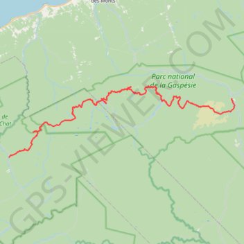
La Traversée des Chic-Chocs
Randonnée entre Les Méchins et Cap-au-Renard. #Randonnée
- Distance: 59.7 mi
- Elevation gain: 15,509 ft
- Maximum elevation: 3,724 ft
- Elevation loss: 15,141 ft
- Minimum elevation: 433 ft
Interactive map
GPS track profile
About this GPS track
Name: La Traversée des Chic-Chocs GPS track, route, trail
Coordinates: 48.82926 -66.75050 48.96130 -66.11337
Other GPS tracks
Click on a GPS track to view route, its statistics and profile.
Matane - Sainte-Anne-des-Monts
Canada > Quebec > La Matanie > Matane
Saint Lawrence River. #Bike #Matane #SainteAnneDesMonts #SaintLawrence
Distance: 55.2 mi • Elevation gain: 2,585 ft • Maximum elevation: 295 ft