Antigonish - Whycocomagh
Gulf of Saint Lawrence. Cape Breton Island. #Bike #Antigonish #Whycocomagh #SaintLawrence #CapeBreton
- Distance: 64.6 mi
- Elevation gain: 2,923 ft
- Maximum elevation: 443 ft
- Elevation loss: 2,858 ft
- Minimum elevation: -7 ft
Interactive map
GPS track profile
About this GPS track
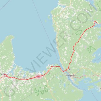
Name: Antigonish - Whycocomagh GPS track, route, trail
Coordinates: 45.58864 -61.99721 45.97546 -61.10311
Other GPS tracks
Click on a GPS track to view route, its statistics and profile.
Pictou - Antigonish
Canada > Nova Scotia > Town of Pictou > Pictou
Gulf of Saint Lawrence. #Bike #Pictou #Antigonish #SaintLawrence #Atlantic
Distance: 63.3 mi • Elevation gain: 2,651 ft • Maximum elevation: 482 ft
Pictou - Antigonish
Canada > Nova Scotia > Town of Pictou > Pictou
#Bike #Pictou #Antigonish
Distance: 46.2 mi • Elevation gain: 2,441 ft • Maximum elevation: 505 ft