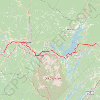
Upper Kingsclear - Coles Island
#Bike #UpperKingsclear #ColesIsland
- Distance: 78.9 mi
- Elevation gain: 2,310 ft
- Maximum elevation: 249 ft
- Elevation loss: 2,444 ft
- Minimum elevation: 0 ft
Interactive map
GPS track profile
About this GPS track
Name: Upper Kingsclear - Coles Island GPS track, route, trail
Coordinates: 45.82437 -66.91704 45.96842 -65.74479
Other GPS tracks
Click on a GPS track to view route, its statistics and profile.
Woolastook Park Loop
Canada > New Brunswick > Kingsclear Parish
#Hike #MTB #Loop #Woolastook
Distance: 3.4 mi • Elevation gain: 276 ft • Maximum elevation: 276 ft
Coles Island - Moncton
Canada > New Brunswick > Johnston Parish
Distance: 56.5 mi • Elevation gain: 1,926 ft • Maximum elevation: 443 ft
Upper Kingsclear - Carters Point
Canada > New Brunswick > Kingsclear Parish
Saint John River. #Bike
Distance: 77.8 mi • Elevation gain: 3,379 ft • Maximum elevation: 397 ft
Woodstock - Upper Kingsclear
Canada > New Brunswick > Woodstock Parish > Woodstock
Saint John River. #Bike #Woodstock #UpperKingsclear #SaintJohn
Distance: 47.9 mi • Elevation gain: 1,929 ft • Maximum elevation: 328 ft