Spences Bridge - Cache Creek
Thompson River. #Bike #SpencesBridge #CacheCreek #Thompson
- Distance: 30.3 mi
- Elevation gain: 2,290 ft
- Maximum elevation: 1,680 ft
- Elevation loss: 1,411 ft
- Minimum elevation: 771 ft
Interactive map
GPS track profile
About this GPS track
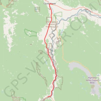
Name: Spences Bridge - Cache Creek GPS track, route, trail
Coordinates: 50.42451 -121.35714 50.81180 -121.28107
Other GPS tracks
Click on a GPS track to view route, its statistics and profile.
Cache Creek - Kamloops
Canada > British Columbia > Thompson-Nicola Regional District > Cache Creek
Distance: 54.0 mi • Elevation gain: 3,655 ft • Maximum elevation: 2,415 ft
Boston Bar - Spences Bridge
Canada > British Columbia > Fraser Valley Regional District > Area A (Boston Bar/North Bend/Canyon Alpine) > Canyon Alpine
Fraser River. #Bike
Distance: 47.8 mi • Elevation gain: 4,029 ft • Maximum elevation: 1,198 ft