Shoal Lake - Neepawa
Interactive map
GPS track profile
About this GPS track
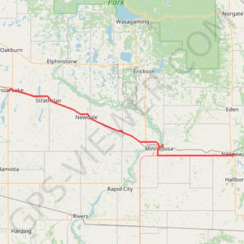
Name: Shoal Lake - Neepawa GPS track, route, trail
End: Neepawa, Division No. 15, Manitoba, R0J 1H0, Canada (50.22916 -99.45491)
Coordinates: 50.22578 -100.59346 50.44177 -99.45479
Other GPS tracks
Click on a GPS track to view route, its statistics and profile.
Neepawa - Portage la Prairie
Canada > Manitoba > Division No. 15 > Neepawa
#Bike #Neepawa #PortageLaPrairie
Distance: 62.7 mi • Elevation gain: 253 ft • Maximum elevation: 1,165 ft