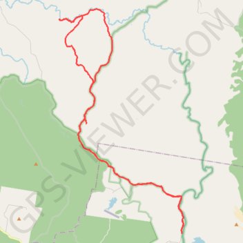
Harrys Hut - Neebs Waterhole
Great Sandy National Park. #MTB #Loop #GreatSandy
- Distance: 31.2 mi
- Elevation gain: 1,562 ft
- Maximum elevation: 312 ft
- Elevation loss: 1,562 ft
- Minimum elevation: 10 ft
Interactive map
GPS track profile
About this GPS track
Name: Harrys Hut - Neebs Waterhole GPS track, route, trail
Start: Cooloola Wilderness Trail, Como, Noosa Shire, Queensland, 4580, Australia (-26.19149 153.03001)
End: Cooloola Wilderness Trail, Como, Noosa Shire, Queensland, 4580, Australia (-26.19151 153.02994)
Coordinates: -26.19158 152.94794 -26.05652 153.03090
Other GPS tracks
Click on a GPS track to view route, its statistics and profile.
Great Sandy National Park - Toolara Forest
#MTB #Loop #GreatSandy #Toolara
Distance: 54.9 mi • Elevation gain: 3,041 ft • Maximum elevation: 335 ft