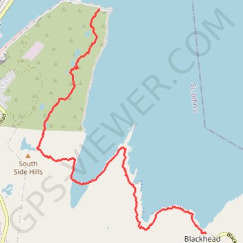
East Coast Trail - Deadmans Bay Path
- Distance: 6.2 mi
- Elevation gain: 1,444 ft
- Maximum elevation: 722 ft
- Elevation loss: 1,480 ft
- Minimum elevation: -3 ft
Interactive map
GPS track profile
About this GPS track
Name: East Coast Trail - Deadmans Bay Path GPS track, route, trail
Coordinates: 47.52551 -52.69837 47.56356 -52.65608
Other GPS tracks
Click on a GPS track to view route, its statistics and profile.
Whitbourne - St. John's
Canada > Newfoundland and Labrador > Whitbourne
#Bike #Whitbourne #StJohns #Newfoundland #Atlantic
Distance: 64.2 mi • Elevation gain: 4,035 ft • Maximum elevation: 768 ft