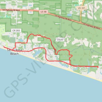
MTB Loop from Dune Allen Beach
Mountain Bike loop via Point Washington State Forest. #MTB #Loop #Atlantic #Ocean #Gulf #Sea #Forest #Nature #City
- Distance: 11.7 mi
- Elevation gain: 203 ft
- Maximum elevation: 59 ft
- Elevation loss: 203 ft
- Minimum elevation: 16 ft
- Moving time: 1 h 29 m
- Moving speed: 7.8 mph
- Maximum speed: 24.8 mph
- Total time: 1 h 56 m
- Global speed: 6.0 mph
- Date: 03/24/2018
Interactive map
GPS track profile
About this GPS track
Name: MTB Loop from Dune Allen Beach GPS track, route, trail
Coordinates: 30.33602 -86.23888 30.35822 -86.16714
Topography: Walton County topographic map