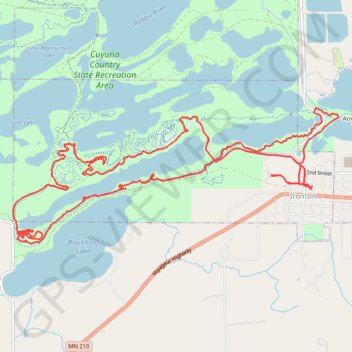
Cuyuna MTB Loop
Mountain Bike loop in Cuyuna Country State Recreation Area. #MTB #Loop #Lake #Forest #Nature
- Distance: 9.5 mi
- Elevation gain: 577 ft
- Maximum elevation: 1,289 ft
- Elevation loss: 577 ft
- Minimum elevation: 1,201 ft
- Moving time: 1 h 23 m
- Moving speed: 6.8 mph
- Maximum speed: 21.2 mph
- Total time: 1 h 23 m
- Global speed: 6.8 mph
- Date: 08/19/2021
Interactive map
GPS track profile
About this GPS track
Name: Cuyuna MTB Loop GPS track, route, trail
Start: 304, Curtis Avenue, Ironton, Crow Wing County, Minnesota, 56455, United States (46.47841 -93.97628)
End: 340, Curtis Avenue, Ironton, Crow Wing County, Minnesota, 56455, United States (46.47812 -93.97645)
Coordinates: 46.47255 -94.02053 46.48631 -93.97238
Topography: Crow Wing County topographic map