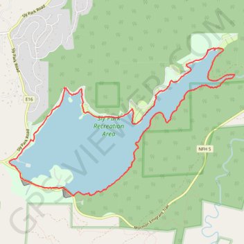
Jenkinson Lake Loop
Hike / Run / Mountain Bike loop around Jenkinson Lake, Pollock Pines. #Hike #Run #MTB #Loop #Lake #Forest #Nature
- Distance: 8.1 mi
- Elevation gain: 958 ft
- Maximum elevation: 3,622 ft
- Elevation loss: 958 ft
- Minimum elevation: 3,461 ft
- Moving time: 1 h 32 m
- Moving speed: 5.3 mph
- Maximum speed: 23.9 mph
- Total time: 2 h 53 s
- Global speed: 4.0 mph
- Date: 09/23/2007
Interactive map
GPS track profile
About this GPS track
Name: Jenkinson Lake Loop GPS track, route, trail
Start: Mormon Emigrant Trail, El Dorado County, California, 95726, United States (38.71737 -120.57097)
End: Mormon Emigrant Trail, El Dorado County, California, 95726, United States (38.71736 -120.57096)
Coordinates: 38.71459 -120.57326 38.73732 -120.52871
Topography: El Dorado County topographic map
Other GPS tracks
Click on a GPS track to view route, its statistics and profile.
Chester - Walker
États-Unis d'Amérique > Californie > Plumas County > Chester
Vélo. En aller simple entre Chester et Walker. #Vélo
Distance: 238.5 mi • Elevation gain: 19,974 ft • Maximum elevation: 8,337 ft