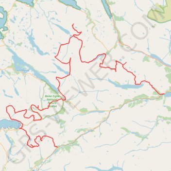
English (United States)
English (Australia)
English (Canada)
English (Hong Kong)
English (India)
English (Ireland)
English (Israel)
English (New Zealand)
English (Philippines)
English (Singapore)
English (South Africa)
English (United Kingdom)
English (United States)
English (Zimbabwe)
Français (Belgique)
Français (Canada)
Français (France)
Français (Luxembourg)
Français (Suisse)
GPS tracks
visualization and sharing, free and without registration.
Import a
GPX
file
projet__cosse_munro(1)
GPS tracks
>
Royaume-Uni
>
Écosse
>
Highland
>
Lochluichart
>
projet__cosse_munro(1)
Distance
:
124.2 mi
Elevation gain
:
42,277 ft
Maximum elevation
:
3,543 ft
Elevation loss
:
42,352 ft
Minimum elevation
:
13 ft
Download
GPS track
Interactive map
Share this GPS track on...
GPS track profile
About this GPS track
Name
: projet__cosse_munro(1) GPS track, route, trail.
Start
:
Lochluichart, Highland, Écosse, IV23 2PZ, Royaume-Uni
(
57.62183
-4.80848
)
End
:
Achnashellach, A890, Balnacra, Highland, Écosse, IV54 8YU, Royaume-Uni
(
57.48201
-5.33356
)
Coordinates
:
57.48128 -5.58438 57.80713 -4.80640
Topography
:
projet__cosse_munro(1) topographic map