The Storr - ascent
GPX file from Walkhighlands; file is copyright Walkhighlands and must not be publicly shared on other websites. Do not remove this notice.
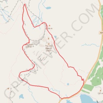
- Distance: 4.9 mi
- Elevation gain: 1,867 ft
- Maximum elevation: 2,323 ft
- Elevation loss: 1,867 ft
- Minimum elevation: 502 ft
Interactive map
GPS track profile
About this GPS track
Name: The Storr - ascent GPS track, route, trail
Start: A855, Highland, Écosse, IV51 9HX, Royaume-Uni (57.49769 -6.15936)
End: A855, Highland, Écosse, IV51 9HX, Royaume-Uni (57.49771 -6.15937)
Coordinates: 57.49393 -6.18765 57.51635 -6.15910
Other GPS tracks
Click on a GPS track to view route, its statistics and profile.
The Old Man of Storr
Royaume-Uni > Écosse > Highland
GPX file from Walkhighlands; file is copyright Walkhighlands and must not be publicly shared on other websites. Do not remove this notice.
Distance: 3.2 mi • Elevation gain: 1,099 ft • Maximum elevation: 1,617 ft
Skye Trail
Royaume-Uni > Écosse > Highland > Shulista
Distance: 79.2 mi • Elevation gain: 12,989 ft • Maximum elevation: 2,149 ft
Hebrideanway
Royaume-Uni > Écosse > Na h-Eileanan Siar > Baile Bhatarsaigh
Distance: 200.3 mi • Elevation gain: 13,773 ft • Maximum elevation: 879 ft