🚶 Trace, boucle de Terre de bas
🌍 Tag :
#FranceTourisme #OfficeTourisme #RandonnéesFrance
🚶 Par - Bons plans en France ,Outre-mers :
https://www.google.com/maps/d/embed?mid=1VJ6s4u13Cn0OaTEAOgdmNOh9tNxCCnno
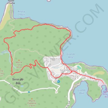
- Distance: 4.2 mi
- Elevation gain: 1,050 ft
- Maximum elevation: 787 ft
- Elevation loss: 981 ft
- Minimum elevation: 7 ft
- Moving time: 1 h 24 m
- Moving speed: 3.0 mph
- Maximum speed: 9.7 mph
- Total time: 1 h 31 m
- Global speed: 2.8 mph
- Date: 04/18/2017
Interactive map
GPS track profile
About this GPS track
Name: 🚶 Trace, boucle de Terre de bas GPS track, route, trail
End: Grande Anse, Terre-de-Bas, Basse-Terre, Guadeloupe, 97136, France (15.85719 -61.62307)
Coordinates: 15.85488 -61.63686 15.86672 -61.61625
Other GPS tracks
Click on a GPS track to view route, its statistics and profile.
Etang
France > Guadeloupe > Terre-de-Bas
Distance: 3.2 mi • Elevation gain: 1,004 ft • Maximum elevation: 784 ft