Houelmont
- Distance: 0.9 mi
- Elevation gain: 289 ft
- Maximum elevation: 1,332 ft
- Elevation loss: 285 ft
- Minimum elevation: 1,158 ft
Interactive map
GPS track profile
About this GPS track
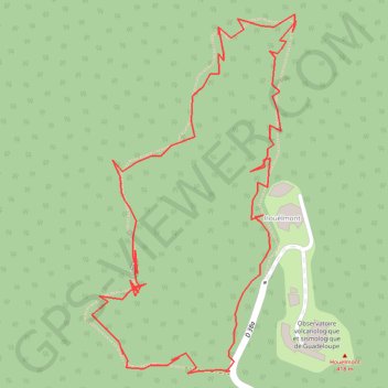
Name: Houelmont GPS track, route, trail
Start: D 38a, Gourbeyre, Basse-Terre, Guadeloupe, 97113, France (15.97942 -61.70416)
End: D 38a, Gourbeyre, Basse-Terre, Guadeloupe, 97113, France (15.97943 -61.70412)
Coordinates: 15.97941 -61.70540 15.98261 -61.70351
Other GPS tracks
Click on a GPS track to view route, its statistics and profile.