Dry Fork Narrows, Peek-A-Boo and Spooky Slot Canyons Loop
Interactive map
GPS track profile
About this GPS track
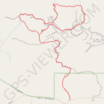
Name: Dry Fork Narrows, Peek-A-Boo and Spooky Slot Canyons Loop GPS track, route, trail
Start: BLM Road 252, Utah, United States (37.46559 -111.21231)
End: BLM Road 252, Utah, United States (37.46559 -111.21233)
Coordinates: 37.46559 -111.22555 37.48556 -111.20837
Topography: Utah topographic map
Other GPS tracks
Click on a GPS track to view route, its statistics and profile.
Peek-a-Boo Slot Canyon, Spooky Slot Canyon and Dry Fork Narrows Loop
Loop hike via Lower Dry Fork Trail, Peek-a-Boo Slot Canyon, Spooky Slot Canyon, Dry Fork Coyote Gulch Trail and Dry Fork Narrows Trail in the Scorpion Wilderness Study Area and the Grand Staircase-Escalante National Monument. #Hike #Loop #Canyon #Nature #Wilderness
Distance: 3.7 mi • Elevation gain: 548 ft • Maximum elevation: 4,961 ft