Cataract Falls
Interactive map
GPS track profile
About this GPS track
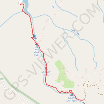
Name: Cataract Falls GPS track, route, trail
Start: Cataract Trail, Marin County, California, 94970, United States (37.93651 -122.63803)
End: Cataract Trail, Marin County, California, 94970, United States (37.93653 -122.63804)
Coordinates: 37.92340 -122.63804 37.93656 -122.62695
Topography: Marin County topographic map
Other GPS tracks
Click on a GPS track to view route, its statistics and profile.
Point Reyes Loop
United States > California > Marin County > Mill Valley
Distance: 62.3 mi • Elevation gain: 6,234 ft • Maximum elevation: 774 ft