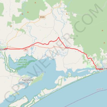
Bairnsdale - Lakes Entrance
#Bike
- Distance: 23.9 mi
- Elevation gain: 1,043 ft
- Maximum elevation: 299 ft
- Elevation loss: 1,060 ft
- Minimum elevation: 3 ft
Interactive map
GPS track profile
About this GPS track
Name: Bairnsdale - Lakes Entrance GPS track, route, trail
End: Esplanade, Lakes Entrance, Shire of East Gippsland, Victoria, 3909, Australia (-37.88128 147.98641)
Coordinates: -37.88298 147.63746 -37.79260 147.98641
Other GPS tracks
Click on a GPS track to view route, its statistics and profile.
Sale - Bairnsdale
#Bike
Distance: 44.7 mi • Elevation gain: 833 ft • Maximum elevation: 180 ft