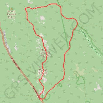
Sullivan Rock - Mount Vincent - Mount Cuthbert
Interactive map
GPS track profile
About this GPS track
Name: Sullivan Rock - Mount Vincent - Mount Cuthbert GPS track, route, trail
Start: Albany Highway, Mount Cooke, Shire Of Wandering, Western Australia, Australia (-32.37964 116.25082)
End: Albany Highway, Mount Cooke, Shire Of Wandering, Western Australia, Australia (-32.38011 116.25044)
Coordinates: -32.38119 116.24166 -32.32651 116.27722
Other GPS tracks
Click on a GPS track to view route, its statistics and profile.
Sullivan Rock - Mount Cooke
Australia > Western Australia > Jarrahdale
#Hike
Distance: 6.0 mi • Elevation gain: 1,204 ft • Maximum elevation: 1,847 ft
Three Mountains Circuit: Mount Vincent - Mount Cuthbert - Mount Randall
Australia > Western Australia > Jarrahdale
Bibbulmun Track. Monadnocks Conservation Park. #Hike #Loop #Monadnocks
Distance: 9.1 mi • Elevation gain: 1,385 ft • Maximum elevation: 1,657 ft
Perth to Sydney
Australie > Australie occidentale > City of Belmont
Distance: 2,362.0 mi • Elevation gain: 47,762 ft • Maximum elevation: 3,802 ft