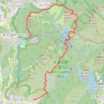
Parview - Mont Butler - Reservoirs - Repulse Bay
Randonnée pédestre. En aller simple. #Randonnée
- Distance: 5.2 mi
- Elevation gain: 1,253 ft
- Maximum elevation: 1,345 ft
- Elevation loss: 2,077 ft
- Minimum elevation: 118 ft
- Moving time: 1 h 18 m
- Moving speed: 4.0 mph
- Maximum speed: 9.3 mph
- Total time: 1 h 20 m
- Global speed: 3.9 mph
- Date: 11/23/2013
Interactive map
GPS track profile
About this GPS track
Name: Parview - Mont Butler - Reservoirs - Repulse Bay GPS track, route, trail
Coordinates: 22.23850 114.19696 22.26922 114.21475
Other GPS tracks
Click on a GPS track to view route, its statistics and profile.
雙潭渣大
China > Hong Kong > Hong Kong Island
Distance: 4.2 mi • Elevation gain: 1,158 ft • Maximum elevation: 1,001 ft
Wilson Trail
China > Hong Kong > Hong Kong Island
#Hike
Distance: 8.1 mi • Elevation gain: 3,386 ft • Maximum elevation: 1,345 ft
Hong Kong island ride
China > Hong Kong > Hong Kong Island
#Bike
Distance: 38.4 mi • Elevation gain: 7,060 ft • Maximum elevation: 1,657 ft
Wilson Trail Full Route
China > Hong Kong > Hong Kong Island
Distance: 50.5 mi • Elevation gain: 14,534 ft • Maximum elevation: 2,011 ft
Jardine's Lookout
China > Hong Kong > Hong Kong Island
#Hike
Distance: 3.8 mi • Elevation gain: 1,148 ft • Maximum elevation: 1,345 ft
Trail Planner Map
China > Hong Kong > Hong Kong Island
Distance: 12.6 mi • Elevation gain: 3,776 ft • Maximum elevation: 1,388 ft